Trees Across Time: An Arboreal History of the Boston Common

“Trees Across Time” narrates the history of the Boston Common with trees as the central characters. Rather than understanding trees as passive objects in the background of human society, this project considers trees important figures in their own right. While humans have exerted great influence on the trees of the Boston Common, the many trees in this landscape have also shaped human culture, as well as the physical environment surrounding them. Drawing from the growing academic field of plant humanities, "Trees Across Time" documents the entangled history of humans and trees on the Boston Common (and beyond).

Haskell & Allen, "Boston Common," lithograph, N.D., Harry T. Peters "America on Stone" Lithography Collection, National Museum of American History, Smithsonian Insitute, americanhistory.si.edu/collect….
N.D.

Natural Resources & Colonization

1675

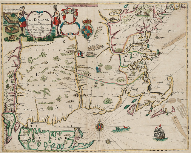
In this 1675 map, trees reveal the British crown's colonial interest in North American natural resources as profitable commodities. Created by John Seller, this map documents the boundaries of the Massachusetts charter of 1628. In the artist's rendering, trees of many shapes and sizes cover the landscape, showing a space that is abundant with both timber and animals (like beavers, rabbits, turkeys, and whales) that were lucrative for global trade. However, the commodification of natural resources put the colonists into conflict with a number of Indigenous tribes who inhabited and maintained the land long before Europeans arrived. In fact, Seller created this map during the first year of King Philip's War: a devastating conflict that erupted after decades of competing land claims between the English, the Wampanoags, and the Narrangasett. The conflict had many environmental factors, including settlers’ livestock destroying Native crops. In his book Changes in the Land: Indians, Colonists, and the Ecology of New England, William Cronon writes that the dispossession of Indigenous populations by Europeans “in New England was as much an ecological as a cultural revolution, and the human side of that revolution cannot be fully understood until it is embedded in the ecological one. Doing so requires a history, not only of human actors, conflicts, and economies, but of ecosystems as well.”

John Seller and John Hills, "A mapp of New England," Map, 1675, Norman B. Leventhal Map & Education Center, collections.leventhalmap.org/s….
1675

Early American Landmarks

1723

This 1723 map of Boston illustrates how a single tree became an important symbol of the Boston Common early in the city's history. At this point, the Common was primarily used for pragmatic reasons that included pastureland, a burial ground, and a military outpost. The map shows one singular tree standing in the center of the Common: likely the "Great Elm," which was already an important landscape marker among colonists, as it was one of the few large trees on the Common. The Great Elm, which likely dated to approximately 1670, is given the same stature on the map as the powder house, highlighting its notable size. In contrast, the seemingly empty landscape surrounding the tree emphasizes how the Common's use was still far more utilitarian than aesthetic, which made trees in general a less prioritized component of the landscape during this era.

John Bonner, "The town of Boston in New England," Map, 1723, Norman B. Leventhal Map & Education Center, collections.leventhalmap.org/s….
1723

The Liberty Tree?

1764

This map, by French map maker Jean Lattré, provides insight about Boston’s international importance circa 1764. Lattré seems to have created the map during or shortly after the conclusion of the Seven Years’ War in 1763, which caused France to lose most of its colonial territory in North America. However, eager to recover its losses from the war and weaken Britain’s power, France continued to monitor colonial unrest in the Americas, including the radical and unruly Bostonians–who resisted aspects British imperial rule (such as the Stamp Act of 1765) by hanging effigies, raiding homes, and rioting in the streets. One decade later, the French became important allies of the American revolutionaries. In Lattré’s 1764 map (created for French authorities), the Common ("commune" in French) once again provides an important landmark for navigating the colonial city. However, the famous Liberty Tree ("Arbre de liberté") is mislabeled. The Liberty Tree stood at the present-day intersection of Washington Street and Essex Street. It seems that Lattré mistook the Liberty tree for the "Great Elm" that stood on the Boston Common until 1876. This map points to what can get lost in translation, and reminds us to view all sources with a critical eye and compare them to other historical documents for verification.

Loading

A City on the Brink

1768

In this colonial era etching, the trees provide insight into a city on the brink of revolution. Although the scene appears tranquil and pastoral, art historian Margaretta Lovell describes it as simmering with "personal turmoil and public enmity." In 1768, the artist and sailor Christian Remick dedicated the original watercolor version of this painting to John Hancock, whose large house is visible in the top right portion of the image. Hancock was a prominent Bostonian and tax-protestor whose ship named Liberty had just been seized by British officials that same year. Now known for his prominent signature on the Declaration of Independence, the seizure of Hancock’s ship caused a riot, which led the British parliament to call for an increased number of troops in the city. In this image, one sees the troops stationed on the Common practicing military drills. On the outskirts of the Common, however, Remick painted a perimeter of trees where the everyday social lives of Bostonians still plays out amid the rising political tensions. Despite the militarized atmosphere, one can glimpse how Bostonians still used the land as they pleased, covered by the shade and relative privacy of the trees. We see a woman sitting in repose; a man eavesdropping on a couple; two men strolling with a dog; and a handful of clandestine lovers–all reminding us that life carries on, even in revolutionary times.

Loading

Banishing Cows

1829

This scene subtly reveals the Common as a utilitarian landscape that was giving way to recreational uses. Drawn by James Kidder in 1829, the image documents the final year that cattle and sheep were allowed to graze on the Common. Families in genteel apparel stroll along the paths, while children chase after a dog. The trees in the center of the image also provide clues about this landscape transformation. In 1728 and 1734, the city of Boston planted a perimeter of trees along Tremont Street to form the shady walk known as the Mall. However, the Common still only had a handful of trees among its grassy expanses throughout most of the 18th century. In 1784, however, the mayor instructed the city to plant additional trees throughout the Common–which are seen here, still in their fairly young state with scaffolding to protect them. The city also leveled much of the ground and added walkways, which crisscrossed the Common by the 1830s. Meanwhile, the few remaining cows in the drawing are pushed to the periphery–a prescient sign of their numbered days on the Common.

Loading

Parks & Public Health

1848

Picturesque trees tower above a massive crowd in this 1848 commemorative lithograph. The vivid scene depicts a celebration of the arrival of the Cochituate Aqueduct’s waters, which flowed into the Common’s Frog Pond for the first time in 1848. In the background, a fountain spews a huge volume of water into the air as countless onlookers watch. Although this level of celebration for a park fountain can be hard to imagine today, the aqueduct was a massive infrastructural feat that marked a new era of public health in Boston. The construction of aqueducts provided Bostonians with a consistent source of fresh water supply for the first time, which dramatically decreased waterborne diseases by replacing unsanitary local drinking sources. Yet, while the fountain looms large in this image, the trees loom even larger, with their lush leaves filling half of the frame. The composition’s attention to both water and trees reflects urban residents’ growing attention to green spaces as significant sites of both recreation and public health.

Loading

Urban Breathing Room

1850

Although New York City’s Central Park was historically referred to as “the lungs of the city,” the same description can be applied to the Boston Common. This 1850 lithograph provides a bird’s eye view of the Common and the Boston Public Garden (established in 1839). In this image by John Bachmann, the rapidly expanding city crowds these luxurious green expanses–which were becoming more important as urbanization and industrialization progressed. The crowded, indecipherable buildings of the city present a sharp contrast to the stark, neat, and vividly-colored arboreal lines of the Common and Garden. The aerial view highlights the perfect symmetry and spacing of the trees, which line the perimeters and walkways of both spaces. Despite the highly designed visual attributes of these green spaces that can make them seem purely ornamental, one can see how the Common and Garden also provided necessary “breathing room” for Bostonians during this era of urban expansion.

Loading

The Great Elm: A Celebrity Tree

1876

In 1876, a fierce winter storm toppled the iconic “Great Elm” of the Boston Common. According to scientific speculation at the time, the magnificent tree stood at the center of the Boston Common for at least two centuries before it fell. In 1825, its dimensions were recorded as 72.5 feet high, 22.5 feet in girth (one foot from the ground), with a canopy of 101 feet in diameter. By the mid-1800s, the massive tree garnered the nickname of “Boston’s oldest inhabitant.” Many Bostonians mythologized the Great Elm as a silent witness to human history. They believed that the elm existed before Boston’s founding in 1630, which allowed it to observe the city's entire history. Although this periodization is questionable (since the tree likely dated to 1670), landscape studies scholar Anne Beamish writes that indulging “the idea that this elm witnessed the extraordinary events of the city and the founding of the nation thrilled Bostonians. Poets and writers revelled in the tree’s ‘dumb witness’ to the past.” After the tree’s death, Robert Waterson even wrote a historical account from the tree’s perspective, titled “Story of the Old Elm on the Boston Common.” When the Great Elm fell in 1876, its demise happened to coincide with the United States’ centennial. For many Bostonians, this timing transformed the tree into not just an iconic symbol of Boston, but of the United States at large.

Loading

Tracking the Trees

1910

In 1910, the Boston Public Grounds Department compiled a scrapbook of photographs that documented and measured the trees of the Boston Common. That same year, the Olmsted Brothers firm conducted an inventory that indicated a total of 812 trees on the Common–which this scrapbook may have been part of. The “Boston Common Trees” photo album feels simultaneously scientific and sentimental. In each photograph, an unidentified man holds a number sign (to label the tree) and a measuring stick (to provide a sense of scale). Despite this somewhat sterile form of photographic documentation in this album, its location in a handmade scrapbook–a medium typically associated with portraits of family and friends–provides a sense of emotional care and connection to the trees. In some of the images, the man places his hand on the tree, as though he is posing with someone familiar. In other photos, park visitors also look into the camera and smile beside the tree, giving the impression of a group portrait. Despite the fact that the Boston Public Grounds Department created this album 115 years ago, humans continue to forge all kinds of connections with trees–ranging from scientific study to deeply personal associations.

Loading

Victory Gardens: A Return to Park Pragmatism

1944

In the 1940s, the City of Boston reintroduced plants and animals not seen on the Common since the 1820s. During World War II, the federal government encouraged citizens and municipalities to create their own “victory gardens” to counteract food shortages induced by the war. The gardens were also seen as potential sources of pride and inspiration. In a government publication titled “Garden for Victory: Guide for Planning the Local Victory Garden Program 1942,” gardens were lauded for their ability to “maintain and improve the morale and spiritual well-being of the individual, family, and Nation. The beautification of the home and community by gardening provides healthful physical exercise, recreation, [and] definite release from war stress and strain.” Boston park officials responded by reintroducing subsistence gardens to the Common. They also used horses to help till the soil, as seen in this photograph (despite the 1830 livestock ban). For a brief time, then, ornamental shade trees once again shared the Common with agricultural plants cultivated for subsistence. Although the Common returned to exclusively recreational use after the war, the Fenway Victory Gardens still remain in Boston as one of the country’s two known remaining World War II victory gardens.

Loading

Parks & Protest

1970

Despite its pastoral appeal, political protests have been part of the Boston Common’s history since the 18th century, at least. Although it was not located on the Common, the famous Liberty Tree of the American Revolution also indicates that environmental landmarks have long been used to both locate and symbolize political struggles. The politicization of parks returned to the Common in 1970, when a large crowd of anti-war demonstrators gathered there. The group consisted of thousands of college students protesting the murder of four college students at Kent State (who were shot by members of the Ohio National Guard), as well as U.S. military actions in Vietnam. If you look closely in the background of the photograph, you can see how protestors used trees as tools of political dissent. Some hung anti-war messages from trees (“My Lai / Kent State / Politicians are Murderers”), while others sat high atop the branches to further dramatize their defiance.

Loading

Ecologies of Care

1983

As the twentieth century progressed, Boston’s dense urban environment put increasing environmental stressors on the Common’s trees. Underground transportation tunnels, heavy foot traffic, and industrial pollutants all take their toll on the city trees. In 1983, the Parks and Recreation Department published construction and improvement plans for Boston Common, one page of which is featured here. The illustration provides a tree-planting guide–complete with steel cables and anchors to keep the tree upright, and specific instructions for mulch depth. The practical guide reveals how much maintenance goes into sustaining the life of a single Boston Common Tree—which illuminates the ongoing time, labor, and financial resources it takes to care for the hundreds of trees that still populate the Common today.

Loading

How To Plant a Tree

1986

Loading

Beyond the Common: "Extending the Beauty of Greenery”

1988

Across the United States, many cities experienced a decline in urban infrastructure investments that largely began in the 1970s. By the late 1980s, the City of Boston made plans to counteract this trend by improving the Midtown area adjacent to the Common. The plan called for more focal points, public plazas, and streetscape improvements. Notably, the plan called for “extending the beauty of greenery and the liveliness of public events [from the Boston Common] into the Cultural District.” Developers hoped to “make the southern edge of Boston Common an outdoor extension of the Cultural District.” They also called for “reactivating” the Liberty Tree Corner through redesigning its small park. Both the Common’s trees and street trees are vividly colored on the map as central components of this Midtown revitalization. While the Common was still celebrated as an exceptional green space, this map reflects a growing desire to also develop and maintain "urban nature" beyond the boundaries of the park.

Loading

Harbingers of Climate Change

2021

Every thirty minutes, a camera affixed to the roof of the ten-story Walker building (owned by Emerson College) takes a photo of part of the Boston Common’s tree canopy. Scientists Wyatt Oswald and Andrew Richardson began this project in 2010, which has resulted in hundreds of thousands of photographs of the trees. The images allow Oswald and Richardson to document patterns and aberrations in the trees’ seasonal shifts–particularly budburst in spring, and senescence (or leaf coloration) and leaf fall in autumn. Their findings have demonstrated that the “green-up” of deciduous forests like the Common are very sensitive to climatic variability. In March 2012, they noted how record-breaking heat in Boston led the trees to leaf out in mid-March, rather than their typical time in early April. Commenting on the larger consequences of this finding, Oswald and Richardson wrote: “if the warmth of March 2012 gives us a sense of what the future holds for springtime in Boston, as climate projections suggest…then we can expect earlier leaf-outs and a substantial lengthening of the growing season. A failure to track these changes could be deleterious to the insect, bird, and mammal species that utilize urban forests as habitat.” Beyond the Boston Common, these phenological changes could shift competitive interactions between tree species, and have a deleterious impact on the carbon balance of forest ecosystems.

Loading

Tree Equity & Environmental Justice

2022

City parks and their verdant plant life are not only sources of respite and scenic beauty. Urban planners now consider green spaces to be important climate-resilient “green infrastructure.” Studies show that parks help mitigate the impacts of climate change by decreasing the urban heat island effect, absorbing stormwater runoff that leads to flooding, reducing fossil fuel emissions from vehicles, and sequestering and storing carbon through plant life. However, green spaces are seldom equally distributed across urban areas–with working class neighborhoods and communities of color often having less access to parks and plant life. This means that the scarcity of plants and green spaces proximate to communities of color contributes, in part, to the unequal harm they suffer from the climate crisis. In “A City of Equal Risks,” cartographer Emily Bowe visualizes how certain social groups in Boston are disproportionately impacted by climate hazards (based on the City’s 2019 Climate Ready Boston report). According to the report, the groups most at risk include: older adults, children, people of color, people with limited English proficiency, people with low or no income, people with disabilities, and people with medical illness. While the map shows that green spaces (including the Common) do mitigate the impact of urban heat in the surrounding area, parks and trees alone cannot rectify the many complex factors that play into climate risk in urban spaces.

Loading

Natural Resources & Colonization

Early American Landmarks

The Liberty Tree?

A City on the Brink

Banishing Cows

Parks & Public Health

Urban Breathing Room

The Great Elm: A Celebrity Tree

Tracking the Trees

Victory Gardens: A Return to Park Pragmatism

Parks & Protest

Ecologies of Care

How To Plant a Tree

Beyond the Common: "Extending the Beauty of Greenery”

Harbingers of Climate Change

Tree Equity & Environmental Justice

800
810
820
830
840
850
860
870
880
890
900
910
920
930
940
950
960
970
980
990
1000
1010
1020
1030
1040
1050
1060
1070
1080
1090
1100
1110
1120
1130
1140
1150
1160
1170
1180
1190
1200
1210
1220
1230
1240
1250
1260
1270
1280
1290
1300
1310
1320
1330
1340
1350
1360
1370
1380
1390
1400
1410
1420
1430
1440
1450
1460
1470
1480
1490
1500
1510
1520
1530
1540
1550
1560
1570
1580
1590
1600
1610
1620
1630
1640
1650
1660
1670
1680
1690
1700
1710
1720
1730
1740
1750
1760
1770
1780
1790
1800
1810
1820
1830
1840
1850
1860
1870
1880
1890
1900
1910
1920
1930
1940
1950
1960
1970
1980
1990
2000
2010
2020
2030
2040
2050
2060
2070
2080
2090
2100
2110
2120
2130
2140
2150
2160
2170
2180
2190
2200
2210
2220
2230
2240
2250
2260
2270
2280
2290
2300
2310
2320
2330
2340
2350
2360
2370
2380
2390
2400
2410
2420
2430
2440
2450
2460
2470
2480
2490
2500
2510
2520
2530
2540
2550
2560
2570
2580
2590
2600
2610
2620
2630
2640
2650
2660
2670
2680
2690
2700
2710
2720
2730
2740
2750
2760
2770
2780
2790
2800
2810
2820
2830
2840
2850
2860
2870
2880
1588
1589
1591
1592
1593
1594
1595
1596
1597
1598
1599
1601
1602
1603
1604
1605
1606
1607
1608
1609
1611
1612
1613
1614
1615
1616
1617
1618
1619
1621
1622
1623
1624
1625
1626
1627
1628
1629
1631
1632
1633
1634
1635
1636
1637
1638
1639
1641
1642
1643
1644
1645
1646
1647
1648
1649
1651
1652
1653
1654
1655
1656
1657
1658
1659
1661
1662
1663
1664
1665
1666
1667
1668
1669
1671
1672
1673
1674
1675
1676
1677
1678
1679
1681
1682
1683
1684
1685
1686
1687
1688
1689
1691
1692
1693
1694
1695
1696
1697
1698
1699
1701
1702
1703
1704
1705
1706
1707
1708
1709
1711
1712
1713
1714
1715
1716
1717
1718
1719
1721
1723
1723
1724
1725
1726
1727
1728
1729
1731
1732
1733
1734
1735
1736
1737
1738
1739
1741
1742
1743
1744
1745
1746
1747
1748
1749
1751
1752
1753
1754
1755
1756
1757
1758
1759
1761
1762
1763
1764
1765
1766
1767
1768
1769
1771
1772
1773
1774
1775
1776
1777
1778
1779
1781
1782
1783
1784
1785
1786
1787
1788
1789
1791
1792
1793
1794
1795
1796
1797
1798
1799
1801
1802
1803
1804
1805
1806
1807
1808
1809
1811
1812
1813
1814
1815
1816
1817
1818
1819
1821
1822
1823
1824
1825
1826
1827
1828
1829
1831
1832
1833
1834
1835
1836
1837
1838
1839
1841
1842
1843
1844
1845
1846
1847
1848
1849
1851
1852
1853
1854
1855
1856
1857
1858
1859
1861
1862
1863
1864
1865
1866
1867
1868
1869
1871
1872
1873
1874
1875
1876
1877
1878
1879
1881
1882
1883
1884
1885
1886
1887
1888
1889
1891
1892
1893
1894
1895
1896
1897
1898
1899
1901
1902
1903
1904
1905
1906
1907
1908
1909
1911
1912
1913
1914
1915
1916
1917
1918
1919
1921
1922
1923
1924
1925
1926
1927
1928
1929
1931
1932
1933
1934
1935
1936
1937
1938
1939
1941
1942
1943
1944
1945
1946
1947
1948
1949
1951
1952
1953
1954
1955
1956
1957
1958
1959
1961
1962
1963
1964
1965
1966
1967
1968
1968
1969
1971
1972
1973
1974
1975
1976
1977
1978
1979
1981
1982
1983
1984
1985
1986
1987
1988
1989
1991
1992
1993
1994
1995
1996
1997
1998
1999
2001
2002
2003
2004
2005
2006
2007
2008
2009
2011
2012
2013
2014
2015
2016
2017
2018
2019
2021
2022
2023
2024
2025
2026
2027
2028
2029
2031
2032
2033
2034
2035
2036
2037
2038
2039
2041
2042
2043
2044
2045
2046
2047
2048
2049
2051
2052
2053
2054
2055
2056
2057
2058
2059
2061
2062
2063
2064
2065
2066
2067
2068
2069
2071
2072
2073
2074
2075
2076
2077
2078
2079
2081
2082
2083
2084
2085
2086
2087
2088
2089
2091
2092
2093
2094
2095
2096
2097
2098
2099
2101
2102
2103
2104
2105
2106
2107
TimelineJS